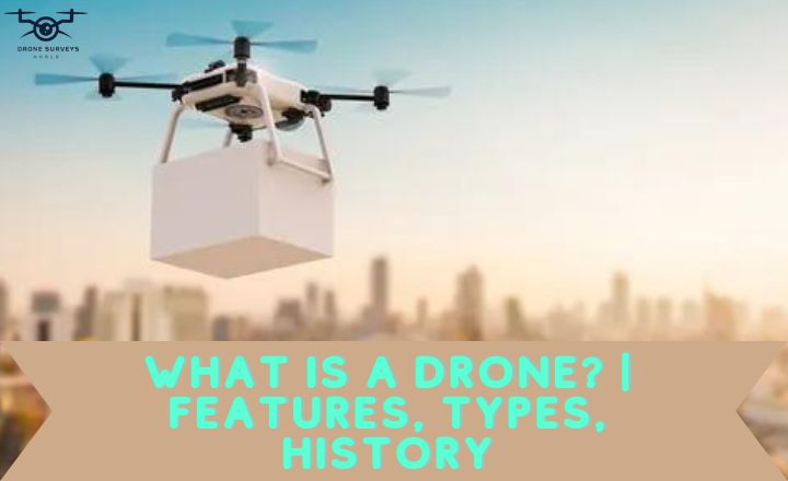
Drones have changed how we collect information and do surveys. Whether you’re new to drones or a pro wanting to use aerial data, knowing how to do a drone survey is essential. Picture flying high, taking amazing views and detailed data with your joystick. This guide will show you how to do aerial mapping and get data successfully. Prepare to make the most of your drone as we explore this exciting precision, technique, and adventure journey.
Key Components Of A Drone Survey
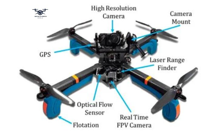
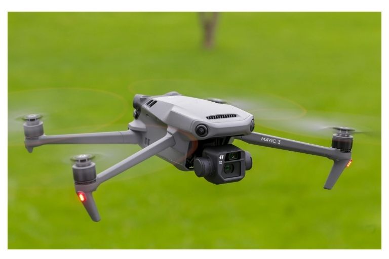
Drone hardware is essential for a thriving drone survey. High-resolution cameras, GPS systems, and obstacle avoidance sensors are important for gathering data. The quality of these components affects the accuracy of the aerial images collected during a survey.
Advances in drone tech have introduced specialized options like LiDAR sensors and thermal cameras, enhancing drones’ abilities for different survey tasks.
Drone Hardware
The flight controller is like the brain of the drone, guiding its flight. It is important for accurate aerial drone survey. The GPS module helps drones fly on their own during surveys by tracking the drone’s location precisely. Cameras on drones take good pictures from various heights, which are useful for industries such as farming, construction, and environmental research.
The cameras help drones quickly gather visual data, making them essential for surveys. Drones also have a communication system that connects them to control stations. This system allows operators to monitor flights, adjust settings, and receive live drone data, making drone surveys more efficient and safe.
GPS System
The GPS is critical for drone surveys because it helps drones collect accurate data and take detailed images. Advanced GPS technology allows drones to work efficiently. Integrating GPS systems in drone surveys has improved mapping and modeling by enhancing the ability to capture geospatial data.
Real-time tracking of drone movements with GPS helps operators monitor progress and adjust during missions. GPS makes drone surveys more versatile and accurate, providing insights that traditional methods cannot.
Camera And Sensors
LiDAR sensors play a crucial role in collecting accurate elevation data by emitting laser pulses and measuring the time it takes for the signals to bounce back. This allows for the creation 3D models that can provide detailed topographic information.
Infrared sensors are essential for capturing thermal images that reveal patterns not visible to the naked eye. By combining these different types of sensors with high-resolution cameras, drone surveys can produce comprehensive, detailed datasets that greatly benefit various industries.
These advanced technologies enable drones to go beyond essential visual imaging and expand their agriculture, construction, and environmental monitoring capabilities. Through precise data collection and analysis, drones equipped with cameras and sensors can identify crop health issues, monitor construction progress in real time, or detect changes in vegetation cover. The ability to customize these critical components according to specific project needs highlights the versatility and adaptability of drone technology in modern surveying practices.
Batteries And Charging Systems
A reliable battery and charging system are essential for successful drone operations. The efficiency and effectiveness of drone batteries depend on factors like power requirements. Knowing your drone’s power needs will help you decide how many spare batteries to bring for a survey. Quality batteries can improve flight time and performance.
The charging system you pick is essential, too. A fast system reduces downtime between flights, allowing for more flights in less time. Consider portability and ease of use when choosing a charging system, especially for longer trips. Balancing battery capacity, charging speed, and convenience is crucial for maximizing productivity during drone surveys.
Drone Software
Drone software is changing how agriculture works. Farmers use drones with special software to check on crops, find pests, and improve irrigation. This saves time and resources and helps produce more crops while being kinder to the environment.
Drones can do more than collect data – they can fly independently and avoid obstacles. This is important for safety in places like construction sites or disaster areas. With improvements in artificial intelligence and machine learning, there are endless ways to make drones better with new software.
Flight Planning
Flight planning software for drones is helpful because it finds the best route for the drone to save energy and get good data. It considers things like wind and ensures the drone uses its battery well. This saves time and money for both casual and professional drone users. The software also helps keep drone flights safe.
It limits where the drone can go and how high it can fly, preventing accidents and keeping it out of restricted areas. With real-time monitoring, operators can watch the drone and change its path to avoid obstacles. This focus on safety protects people and equipment, showing how technology can reduce risks in drone use.
Data Processing
Data processing software is essential for turning raw drone data into valuable insights and actionable results. It can create detailed maps and 3D models, helping users get helpful information from aerial surveys with high accuracy. The software has advanced tools for analyzing data, which lets users find hidden patterns that can help with decision-making.
Users can customize the software to fit the needs of their projects, making survey operations more efficient and results better suited to different industries. These features allow organizations to find new ways to grow and innovate in the digital world.
Reporting And Visualization
Reporting and visualization software tools are essential for turning drone data into valuable insights. These tools help users create detailed reports that show vital trends and anomalies in their data. Visualizations like heat maps and 3D models make it easy for stakeholders to understand the information quickly.
Combining reporting software with drone technology has changed the agriculture, construction, and environmental monitoring industries. Users can now monitor crop health, track construction progress, and assess ecological changes accurately. This connection between drone data and analysis tools has improved decision-making in different fields.
How To Do A Drone Survey
Preparing for a drone survey involves more than just flying a drone. It requires understanding the project’s needs for data collection, analyzing site conditions, and addressing environmental factors.
How to Do A Drone Survey? For drone land surveying, getting the necessary permits and certifications is critical to complying with regulations and avoiding legal issues. Planning the flight path carefully can save time and resources, ensuring precise and comprehensive data collection.
Launching your drone safely requires skill and adaptability. Be ready to adjust the flight path for obstacles or weather changes. Monitoring your drone’s sensors and cameras during the survey ensures accurate data collection and flight control. Following regulatory guidelines from takeoff to landing ensures safety and data integrity while navigating hazards cautiously.
After your drone survey, use software tools to turn the data into useful information. This helps you create detailed maps and models that better understand the surveyed areas. This analysis adds value to your survey by showing terrain features and structures not easily seen from the ground, changing how we see and understand our surroundings from above.
Preparing For A Drone Survey
Knowing what data you need is essential to plan a successful drone survey, like images or 3D models. Understanding what your drone can and can’t do would be best. Before starting the study, check the site and surroundings for risks and ways to get the best results. The drone, equipped with state-of-the-art technology, aims to revolutionize how we conduct drone site surveys.

Understanding The Project Requirements
This means knowing what kind of data is required in terms of quality and format. This detailed understanding helps plan and carry out the survey accurately to meet the project’s goals. By knowing the project requirements well, you can anticipate and deal with any challenges that might come up during the survey.
This preparation allows for quick problem-solving and adjustment of strategies to overcome obstacles effectively. Understanding the project requirements is critical to a successful drone survey that provides customized results to meet specific needs and expectations.
Assessing The Site And Environmental Factors
It can disrupt the drone’s signals and cause control problem. Conducting a pre-flight assessment to identify interference areas and taking precautions will help ensure a successful mission.
Weather conditions at the survey location are also crucial. Bad weather, like strong winds, rain, or fog, can affect the drone’s flight and data quality. Monitoring weather forecasts and rescheduling flights if necessary can help drone operators avoid risks and maintain safety.
Obtaining Necessary Permissions And Certifications
When getting ready for a drone survey, it’s essential to make sure you have all the necessary permissions and certifications. This step is crucial for a successful and legal operation. Talking to local authorities and regulatory bodies early in the planning process can help speed up the approval process and avoid delays.
Knowing the specific rules and restrictions for drone operations in your area is also vital. Different places have different rules about where drones can fly, how high they can go, and what permits are needed for commercial use. Understanding these regulations and getting the necessary approvals can prevent legal issues and ensure your survey is done safely and ethically.
Planning The Flight Path And Setting Up Ground Control Points (GCPs)
Drones can quickly move around and collect precise data from different angles by carefully planning the flight path with special software. Ground Control Points are essential in this process because they act as reference points to help align and calibrate the pictures taken by the drone.
Placing GCPs strategically across the surveyed area helps ensure the data is accurately located and reduces mistakes during data processing. Paying close attention to these details during the planning stage leads to better and higher-quality results, like detailed maps or 3D models.
As technology improves, including these careful details in drone survey planning will improve efficiency and accuracy in industries like farming, drone building surveys, and environmental monitoring.
Conducting The Drone Survey
After finding the drone survey area, planning the flight path and altitude is essential.
Launching The Drone
The pilot must control the drone carefully during takeoff to keep the survey accurate. Monitoring the drone’s movement and adjusting as needed is important to stay on track. A pre-flight checklist can confirm all systems are working before starting the survey. Launching the drone starts a planned mission that needs precision and attention.
Being ready for challenges during flight is crucial for a successful survey. Pilots can collect data from above by staying focused and agile, navigating different terrains and conditions. Each launch is a chance to discover and innovate in aerial technology.
Following The Pre-Planned Flight Path
Following the planned flight path carefully ensures the collected data is thorough and meets the project goals. Staying on track helps pilots gather consistent and reliable information, reducing the need for repeat surveys or missing essential data points.
Flying the drone along the set path allows for easy integration of different data sets, giving a complete view of the survey area.
This method improves data analysis and decision-making based on reliable information. Using technology in this way makes workflows smoother and optimizes resource use, leading to more efficient gathering of essential insights from drone surveys.
Capturing Data Using Sensors And Cameras
Sensors collect different data types, such as thermal imaging or LiDAR, for analysis. Cameras provide high-resolution images for mapping and inspection. Integrating sensors and cameras is essential for valuable insights. Sensor technology advancements improve data capture quality.
Monitoring sensor outputs during flight allows for adjustments. Using these technologies streamlines surveys and opens new applications in agriculture, construction, environment monitoring, and disaster response.

Monitoring And Controlling The Drone During The Survey
The drone starts its survey mission with a focus on being precise and careful. Monitor the drone’s height, speed, and surroundings to avoid accidents. Technology now allows pilots to get real-time data and make quick decisions that can significantly impact the survey.
Flying the drone isn’t just about moving it in the air; it’s about collecting and analyzing data. Every drone movement must be carefully planned to ensure accurate information is managed safely and efficiently. Pilots can turn their surveys into valuable experiences that reveal essential information under challenging areas by finding the right balance between control and independence.
Ensuring Safety And Compliance Throughout The Process
During a drone survey, watch the environment and adjust flight plans as needed. Factors like wind, visibility, and restricted areas must be considered for safety and following rules. Regularly checking the drone equipment is crucial to prevent problems.
Pilots should talk to authorities and stakeholders to keep them updated and get permissions. Good communication can solve problems fast and make the survey run smoothly. By being alert, flexible, and communicative, pilots can improve safety and follow rules to survey with drone for a successful operation.
Post-Processing And Analysis
Analyzing drone survey data is essential for getting helpful information. Special software changes the data into actionable details.
Importing Data Into Data Processing Software
After importing drone data into the software, the real work begins. The software uses advanced techniques to turn raw data into valuable insights. This involves cleaning up the data, fixing errors, and preparing it for analysis.
This step is essential to ensure that any findings from the data are accurate. Through analysis, researchers can find patterns and anomalies in the data. They can combine different sources of information to understand a specific area or even better. Organizations can use data processing software to make intelligent decisions based on reliable drone data.
Creating A Point Cloud, Orthomosaic, Or Digital Elevation Model
Import drone data into data processing software to start analyzing it. Use tools in the software to find patterns and insights in the data. Create reports and visuals to help make decisions.
Compare different datasets and track changes over time by overlaying them. This helps in detecting irregularities and anomalies. Researchers can use these tools to uncover hidden potentials in their data and draw meaningful conclusions for fields like agriculture, surveying, and environment monitoring.
Analyzing And Interpreting The Data
Researchers use software tools to examine the data collected during drone flights. They clean and organize the data, analyze it, and create visualizations to share their findings.
Correcting errors in the data is crucial to ensure the accuracy of the analysis. Advanced algorithms can help identify patterns or anomalies in the data that may be useful for decision-making. Through careful post-processing and analysis, researchers can discover hidden relationships and trends in the data.
Conclusion
Using drones to survey is a great way to collect data quickly and effectively. How to Do A Drone Survey? Follow the steps in this guide to have a successful survey. Make safety a priority, follow the rules, and plan your flight path carefully for the best results. With practice, you’ll get better at using drones for surveys. Start using drone technology in your projects now! Enter the drone survey data processing world, where raw imagery and sensor data are transformed into valuable insights and actionable information.
Frequently Asked Questions
How to start a drone survey business?
Good drone equipment and software are essential for getting accurate survey data. Choose a drone that fits your survey needs, like how much it can carry, how long it can fly, and what kind of camera it has. Also, pick the right software to process and analyze data so you can work efficiently and give helpful drone survey information to clients.
How does drone surveying work?
When choosing a drone for surveying, think about flight time, camera quality, and software compatibility. Drones with longer flight times are suitable for covering extensive areas without changing batteries often. Also, drones with high-resolution cameras are essential for taking detailed images for accurate surveys.
Is drone surveying expensive?
Drone surveying may cost a lot at first. It would be best to buy a good drone and software, which can be expensive. But, using drones for drone surveying and mapping is usually cheaper than traditional methods.
